It certainly feels like Ballard is growing faster than other North Seattle neighborhoods. Now there’s visual data that shows that Ballard is absorbing a disproportionate amount of population growth compared to most neighborhoods in our area.
“Last year 88 percent of the city’s new housing was crowded into dense neighborhoods that make up just 18 percent of the city’s residential land area,” explains Seattle Times reporter Mike Rosenberg in a Sunday column.
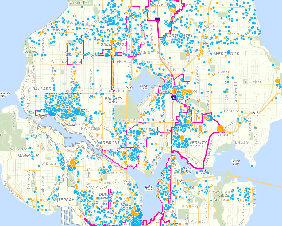
Rosenberg points to this interactive map (image displayed above) which shows the last decade’s worth of new residential buildings (blue dots) and permits issued for upcoming residential buildings (yellow dots.) By looking at the map — updated by the city of Seattle — it certainly appears Ballard has added more residential housing than any other neighborhood in North Seattle over the last decade. The University District and Lower Queen Anne also show a lot of growth.
“So in reality, most of Seattle is not growing – only certain parts are,” Rosenberg writes in the Times. “Single-family neighborhoods like Magnolia, Laurelhurst and Arbor Heights are absorbing virtually no growth.”
Density is a function of zoning. Central Ballard and Crown Hill are designated as “urban villages,” which makes it easier for developers to gain approval for higher-density projects. The University District is the largest urban village in North Seattle, and parts of Fremont, Greenwood, Green Lake, Ravenna, Northgate and other stretches along 99 and I-5 are designated, as well.
While other parts of Seattle are growing faster than Ballard — like South Lake and Capitol Hill — it’s certainly interesting to see how Ballard compares to our other North Seattle neighborhoods. You can browse the map right here.
Update: Central Ballard grew 54.1% in population since 2010, and that’s faster than any North Seattle neighborhood, according to this earlier Seattle Times report by Gene Balk.